
Stránky farnosti sv. Matěje
Losovali tedy a los padl na Matěje - Sk 1,26


3. 6. 2026
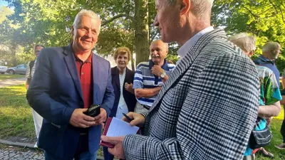
FOTOGALERIE: Vzpomínkové setkání u stromu P. Jana Machače
V pondělí 1. června proběhlo v parku na Hadovce vzpomínkové setkání u stromu P. Jana Machače. Akce se uskutečnila u příležitosti 111. výročí narození bývalého dlouholetého faráře u sv. Matěje.
20. 5. 2026
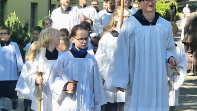
FOTOGALERIE: Svatomatějská pouť
V neděli 17. května jsme společně oslavili pouť patrona našeho kostela sv. Matěje. Po slavnostní bohoslužbě jsme se sešli na farní zahradě na tradiční opékání špekáčků a pohoštění. Zároveň se uskutečnilo setkání bývalých a současných svatomatějských ministrantů. Děkujeme všem za přípravu poutních oslav i těm, kdo se celé akce zúčastnili jako poutníci.

12. 5. 2026
Noc kostelů 29.5.2026
O farnosti
Kostel sv. Matěje
Objevte příběh kostela sv. Matěje, významné náboženské a kulturní stavby, jejíž počátky jsou v kronikách spojovány již s rokem 971.
Více o našem kostelu

Perníkové jesličky
Tradice svatomatějského perníkového betlému sahá až do roku 1972. Přečtěte si více o jeho historii a současnosti.
Více o perníkových jesličkách
